Convenience store nearby Púcara
Argentina
Convenience store nearby Púcara
Púcara
1071, Libertad, C1012, Comuna 1, Buenos Aires, AR Argentina
contacts phone
:
+54 11 4815-8098
Latitude:
-34.5959999
, Longitude:
-58.384195
larger map & directions
read more
nearest Convenience store
355 m
Kiosco Fenja
Avenida Córdoba 1115
Convenience store
read more
357 m
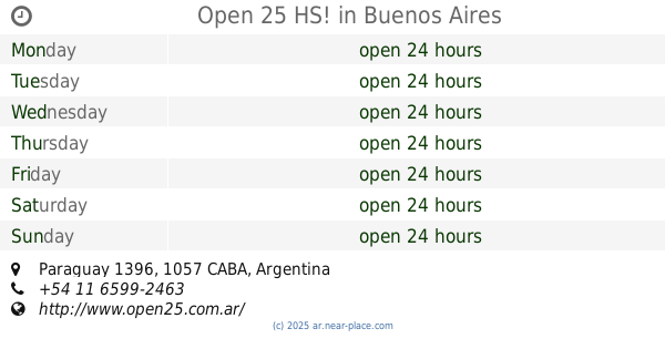
Open 25 HS!
Paraguay 1396
Convenience store
read more
573 m
Kiosco Sam
Esmeralda 899
Convenience store
read more
595 m
Maxikiosco Dimamic Store
Avenida Córdoba 1569
Convenience store
read more
628 m
OPEN 25 HS!
Avenida Córdoba 1598
Convenience store
read more
628 m
Miranda Dario Roberto
Paraguay 747
Convenience store
read more
745 m
Tu Kiosquito
Lavalle 1133
Convenience store
read more
749 m
Kiosco Gómez
Lavalle 1152
Convenience store
read more
755 m
MAXI SHOP
Paraguay 630
Convenience store
read more
755 m
Kiosco Ulpiano
Lavalle 1281
Convenience store
read more
772 m
Silvia Iparraguirre
Tucumán 1505
Convenience store
read more
776 m
MAXIKIOSCO ANITA
Marcelo Torcuato de Alvear 1769
Convenience store
read more
787 m
Kiosco Christen
Lavalle 1392
Convenience store
read more
892 m
Time Crazy
Paraná 430
Convenience store
read more
898 m
Maxikiosco
Avenida Córdoba 543
Convenience store
read more
922 m
Kiosko Leo
Suipacha 438
Convenience store
read more
975 m
Buena Onda
Montevideo 485
Convenience store
read more
983 m
Supermarket DIA - Balvanera
Riobamba 1014, Balvanera
Convenience store
read more
995 m
Miga miga
Uruguay 348
Convenience store
read more
1000 m
OPEN 25 HS!
Marcelo T. de Alvear, 1901
Convenience store
read more
1.001 km
Díaz Galaz René Patricio
Rodríguez Peña 520
Convenience store
read more
1.002 km
V-Ga
Viamonte 1840
Convenience store
read more
1.022 km
Sbarra Maria
Galería Jardín, Florida 537
Convenience store
read more
1.105 km
Maxikiosco del Roi
Esmeralda 317
Convenience store
read more
1.293 km
Kiosco Degli
Avenida Corrientes 1907
Convenience store
read more
📑
all categories
Accounting
Administrative area level 1
Administrative area level 2
Airport
Amusement park
Aquarium
Art gallery
Atm
Bakery
Bank
Bar
Beauty salon
Bicycle store
Book store
Bowling alley
Bus station
Cafe
Campground
Car dealer
Car rental
Car repair
Car wash
Casino
Cemetery
Church
City hall
Clothing store
Colloquial area
Convenience store
Country
Courthouse
Dentist
Department store
Doctor
Electrician
Electronics store
Embassy
Establishment
Finance
Fire station
Florist
Food
Funeral home
Furniture store
Gas station
General contractor
Grocery or supermarket
Gym
Hair care
Hardware store
Health
Hindu Temple
Home goods store
Hospital
Insurance agency
Intersection
Jewelry store
Laundry
Lawyer
Library
Light rail station
Liquor store
Local government office
Locality
Locksmith
Lodging
Meal delivery
Meal takeaway
Mosque
Movie rental
Movie theater
Moving company
Museum
Natural feature
Neighborhood
Night club
Painter
Park
Parking
Pet store
Pharmacy
Physiotherapist
Place of worship
Plumber
Point of interest
Police
Political
Post office
Premise
Real estate agency
Restaurant
Roofing contractor
Route
Rv park, camping
School
Shoe store
Shopping mall
Spa
Stadium
Storage
Store
Subpremise
Subway station
Supermarket
Synagogue
Taxi stand
Train station
Transit station
Travel agency
University
Veterinary care
Zoo
sublocality level 1
sublocality level 3
↑