Gas station nearby Terminal Dapsa Dock Sud
Argentina
Gas station nearby Terminal Dapsa Dock Sud
Terminal Dapsa Dock Sud
Dock Sud, Buenos Aires Province, Argentina
contacts phone
:
+54
Latitude:
-34.6368305
, Longitude:
-58.3382992
larger map & directions
read more
nearest Gas station
446 m
Doke Dok Sud Ypf
Genova, Dock Sud
Gas station
read more
747 m
Refinería Y
Dock Sud
Gas station
read more
1.21 km
YPF Dock Sud
Dock Sud
Gas station
read more
1.25 km
YPF. Planta de GLP
Genova, Dock Sud
Gas station
read more
1.637 km
Lupat Ingenieria SA
Combatientes de Malvinas 1432, Avellaneda
Gas station
read more
1.725 km
Deposito combu
Dock Sud
Gas station
read more
2.011 km
Refineria Shell
Dock Sud
Gas station
read more
2.022 km
RBA
Dock Sud
Gas station
read more
2.044 km
Terminal 130
Necochea 842-808
Gas station
read more
2.075 km
Tuin
Genova 1900, Dock Sud
Gas station
read more
2.098 km
Lavadero
C1155AGH, Benito Pérez Galdos 350
Gas station
read more
2.236 km
gnc
hueego, Nicolás Avellaneda y, Dock Sud
Gas station
read more
2.26 km
Lanza Juan P
Av Billinghurst 1819, Dock Sud
Gas station
read more
2.313 km
Naftas y Gnc Lubricentro Boca - Distribuidor
Avenida Almirante Brown 678
Gas station
read more
2.413 km
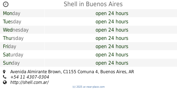
Shell
Avenida Almirante Brown 600
Gas station
read more
2.419 km
Shell
600, Avenida Almirante Brown
Gas station
read more
2.841 km
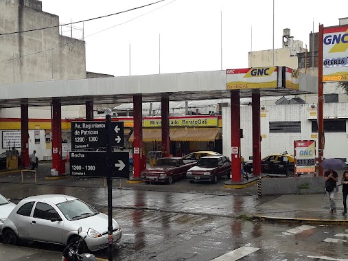
Barato Gas
Rocha 1200
Gas station
read more
2.888 km
Petrobras
Sargento Ponce 2900, Dock Sud
Gas station
read more
2.935 km
YPF
Avenida Regimiento de Patricios, Tristan Suárez
Gas station
read more
2.942 km
Talle Mecánico ItalCar
C1165ADB, Hernandarias 176
Gas station
read more
2.961 km
Destilería Argentina de Petróleo S.A.
Sargento Ponce, Dock Sud
Gas station
read more
3.069 km
Chochi Lavadero
1600 C1269AAH, Azara 1502
Gas station
read more
3.373 km
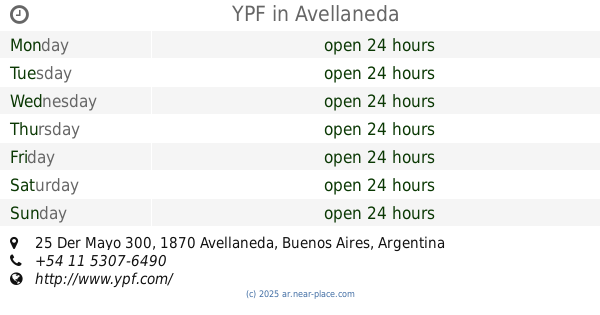
YPF
25 Der Mayo 300, Avellaneda
Gas station
read more
3.544 km
Shell
849, Avenida Paseo Colón
Gas station
read more
3.97 km
YPF
Ruta Provincial 41 Km 265 Entre Calle 215 Y Calle 217, Gral. Belgrano
Gas station
read more
📑
all categories
Accounting
Administrative area level 1
Administrative area level 2
Airport
Amusement park
Aquarium
Art gallery
Atm
Bakery
Bank
Bar
Beauty salon
Bicycle store
Book store
Bowling alley
Bus station
Cafe
Campground
Car dealer
Car rental
Car repair
Car wash
Casino
Cemetery
Church
City hall
Clothing store
Colloquial area
Convenience store
Country
Courthouse
Dentist
Department store
Doctor
Electrician
Electronics store
Embassy
Establishment
Finance
Fire station
Florist
Food
Funeral home
Furniture store
Gas station
General contractor
Grocery or supermarket
Gym
Hair care
Hardware store
Health
Hindu Temple
Home goods store
Hospital
Insurance agency
Intersection
Jewelry store
Laundry
Lawyer
Library
Light rail station
Liquor store
Local government office
Locality
Locksmith
Lodging
Meal delivery
Meal takeaway
Mosque
Movie rental
Movie theater
Moving company
Museum
Natural feature
Neighborhood
Night club
Painter
Park
Parking
Pet store
Pharmacy
Physiotherapist
Place of worship
Plumber
Point of interest
Police
Political
Post office
Premise
Real estate agency
Restaurant
Roofing contractor
Route
Rv park, camping
School
Shoe store
Shopping mall
Spa
Stadium
Storage
Store
Subpremise
Subway station
Supermarket
Synagogue
Taxi stand
Train station
Transit station
Travel agency
University
Veterinary care
Zoo
sublocality level 1
sublocality level 3
↑