Hospital nearby Hospital Ramos Mejía
Argentina
Hospital nearby Hospital Ramos Mejía
Hospital Ramos Mejía
Venezuela & Gral. Urquiza Argentyna
contacts phone
:
+54
Latitude:
-34.6073907
, Longitude:
-58.4097707
read more
nearest Hospital
508 m
Abuelo Dijo
Gallo 479
Hospital
read more
509 m
Brenda 6/7
Boulogne Sur Mer 560, Buenos Aires
Hospital
read more
540 m
Clinica De Rehabilitacion TÍA ANA
Gallo 499
Hospital
read more
628 m
Instituto Medico Rossi
C1173ACC, Sánchez de Loria 117, Buenos Aires
Hospital
read more
661 m
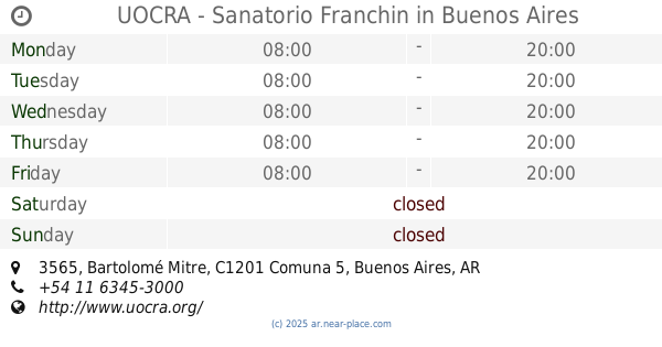
UOCRA - Sanatorio Franchin
Bartolomé Mitre 3565, Buenos Aires
Hospital
read more
703 m
Torre Hotel
Argentina SN-S ESTACIONAMIENTO ESC DE HOTEL, Monterrey
Hospital
read more
757 m
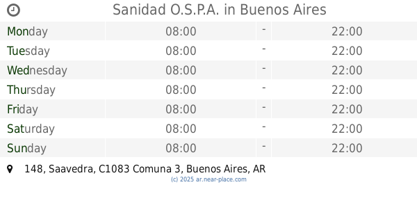
Sanidad O.S.P.A.
Saavedra 148
Hospital
read more
763 m
OSPSA
Saavedra 159
Hospital
read more
816 m
Dr Tacuda
C1031ABL, Calle Paso 594
Hospital
read more
816 m
Dr Tacudd
C1031ABL, Calle Paso 594
Hospital
read more
820 m
CMB
Saavedra 205
Hospital
read more
867 m
Hospital Franchin
Bartolomé Mitre
Hospital
read more
937 m
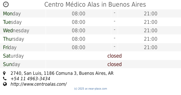
Centro Médico Alas
San Luis 2740
Hospital
read more
962 m
Mevaterapia
Presidente Teniente General Juan Domingo Perón
Hospital
read more
962 m
Mevaterapia
Teniente General Juan Domingo Perón
Hospital
read more
968 m
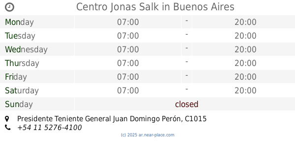
Centro Jonas Salk
Presidente Teniente General Juan Domingo Perón
Hospital
read more
968 m
Jonas Salk Center
Teniente General Juan Domingo Perón
Hospital
read more
968 m
Jonas Salk Center
Presidente Teniente General Juan Domingo Perón
Hospital
read more
991 m
Centro Siarc
Maza 330
Hospital
read more
1.072 km
Sanatorio Finochietto
Avenida Córdoba 2678, Buenos Aires
Hospital
read more
1.085 km
Centro Geriátrico Ntra. Sra. de Lourdes
Colombres 161
Hospital
read more
1.086 km
Finochietto Por Boulogne
C1213AAP, Boulogne Sur Mer 976
Hospital
read more
1.133 km
DMI imagenes
Alberti 447
Hospital
read more
1.231 km
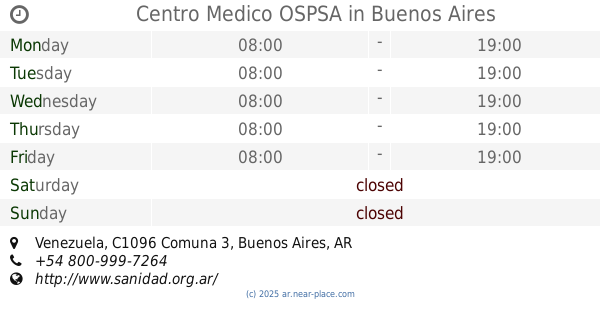
Centro Medico OSPSA
2359, ABO, Venezuela
Hospital
read more
1.318 km
Hospital de Clinicas Jose de San Martin
Avenida Córdoba 2351
Hospital
read more
📑
all categories
Accounting
Administrative area level 1
Administrative area level 2
Airport
Amusement park
Aquarium
Art gallery
Atm
Bakery
Bank
Bar
Beauty salon
Bicycle store
Book store
Bowling alley
Bus station
Cafe
Campground
Car dealer
Car rental
Car repair
Car wash
Casino
Cemetery
Church
City hall
Clothing store
Colloquial area
Convenience store
Country
Courthouse
Dentist
Department store
Doctor
Electrician
Electronics store
Embassy
Establishment
Finance
Fire station
Florist
Food
Funeral home
Furniture store
Gas station
General contractor
Grocery or supermarket
Gym
Hair care
Hardware store
Health
Hindu Temple
Home goods store
Hospital
Insurance agency
Intersection
Jewelry store
Laundry
Lawyer
Library
Light rail station
Liquor store
Local government office
Locality
Locksmith
Lodging
Meal delivery
Meal takeaway
Mosque
Movie rental
Movie theater
Moving company
Museum
Natural feature
Neighborhood
Night club
Painter
Park
Parking
Pet store
Pharmacy
Physiotherapist
Place of worship
Plumber
Point of interest
Police
Political
Post office
Premise
Real estate agency
Restaurant
Roofing contractor
Route
Rv park, camping
School
Shoe store
Shopping mall
Spa
Stadium
Storage
Store
Subpremise
Subway station
Supermarket
Synagogue
Taxi stand
Train station
Transit station
Travel agency
University
Veterinary care
Zoo
sublocality level 1
sublocality level 3
↑