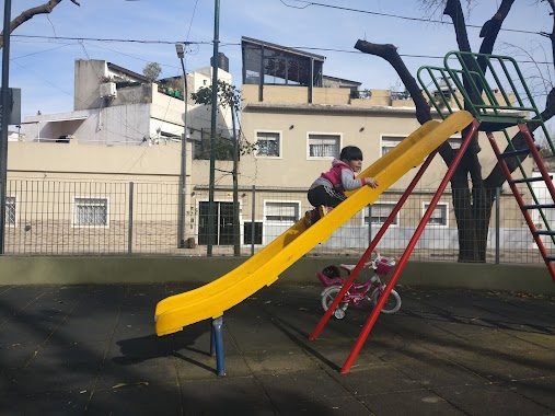
Park nearby Belisario Roldán
Argentina
Park nearby Belisario Roldán
Belisario Roldán
Santo Tomé, Comuna 10, Buenos Aires, AR Argentina
contacts phone
:
+54
Latitude:
-34.6278631
, Longitude:
-58.528793
larger map & directions
read more
nearest Park
200 m
Plaza Villa Herminia
Avenida General Paz 7883, Ciudadela
Park
read more
345 m
Doctor Rodolfo Erausquin Park
Gana 692
Park
read more
345 m
Plazoleta Dr. Rodolfo Erausquin
Gana 692
Park
read more
403 m
Plazoleta Ceferino Namuncurá
Arregui
Park
read more
455 m
Paseo Versalles
Versalles
Park
read more
547 m
Paseo de Versailles
Park
read more
699 m
Plaza Ciudad de Banff
Roma 760
Park
read more
699 m
Banff City Park
Roma 760
Park
read more
743 m
Paseo de Versalles: Sector J. Amalfitani
C1408CBF, Manuel Porcel de Peralta 553
Park
read more
848 m
Plaza Hugo Luis Caramelo
Ciudadela
Park
read more
848 m
Plaza Hugo Lucio Caramelo
Ciudadela
Park
read more
853 m
Plaza Villa Real
José Pedro Varela 5814-5900
Park
read more
898 m
Educativo De Plantas Nativas Solnaturi Garden
Cortina 1830
Park
read more
898 m
Jardín Educativo De Plantas Nativas Solnaturi
Cortina 1830
Park
read more
961 m
Plaza Guatemala
Park
read more
1.006 km
Plazoleta Yugoslavia
Park
read more
1.019 km
Plazoleta Patricias Argentinas
Reconquista 686-694, Ciudadela
Park
read more
1.152 km
Plaza Teran
Nogoyá 5451-5499
Park
read more
1.169 km
Plaza Dr. Juan B. Terán
Melincué 5402-5450
Park
read more
1.26 km
Plaza Patin
Park
read more
1.312 km
Plaza Padre Carlos Mugica
B1702ETU, Juan José Paso 1499-1549, Ciudadela
Park
read more
1.362 km
Monumento a Mariano Moreno
B1702APU, Avenida Gaona 3852-3900, Ciudadela
Park
read more
1.561 km
Plazoleta Alberto Vaccarezza
Alcaraz
Park
read more
2.106 km
Plaza Monsignor Fermín Lafitte
Hilario de Almeira 4800
Park
read more
2.22 km
Plaza Los Andes
Avenida Rivadavia
Park
read more
📑
all categories
Accounting
Administrative area level 1
Administrative area level 2
Airport
Amusement park
Aquarium
Art gallery
Atm
Bakery
Bank
Bar
Beauty salon
Bicycle store
Book store
Bowling alley
Bus station
Cafe
Campground
Car dealer
Car rental
Car repair
Car wash
Casino
Cemetery
Church
City hall
Clothing store
Colloquial area
Convenience store
Country
Courthouse
Dentist
Department store
Doctor
Electrician
Electronics store
Embassy
Establishment
Finance
Fire station
Florist
Food
Funeral home
Furniture store
Gas station
General contractor
Grocery or supermarket
Gym
Hair care
Hardware store
Health
Hindu Temple
Home goods store
Hospital
Insurance agency
Intersection
Jewelry store
Laundry
Lawyer
Library
Light rail station
Liquor store
Local government office
Locality
Locksmith
Lodging
Meal delivery
Meal takeaway
Mosque
Movie rental
Movie theater
Moving company
Museum
Natural feature
Neighborhood
Night club
Painter
Park
Parking
Pet store
Pharmacy
Physiotherapist
Place of worship
Plumber
Point of interest
Police
Political
Post office
Premise
Real estate agency
Restaurant
Roofing contractor
Route
Rv park, camping
School
Shoe store
Shopping mall
Spa
Stadium
Storage
Store
Subpremise
Subway station
Supermarket
Synagogue
Taxi stand
Train station
Transit station
Travel agency
University
Veterinary care
Zoo
sublocality level 1
sublocality level 3
↑