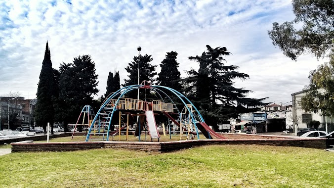
Park nearby Plaza Villa Real
Argentina
Park nearby Plaza Villa Real
Plaza Villa Real
5814-5900, José Pedro Varela, Comuna 10, Buenos Aires, AR Argentina
contacts phone
:
+54
website:
www.buenosaires.gob.ar
Latitude:
-34.620232
, Longitude:
-58.5278382
larger map & directions
read more
nearest Park
440 m
Plaza Patin
Park
read more
459 m
Plazoleta Tres de Febrero
B1703ACB, Román Gómez 1610-1648, José Ingenieros
Park
read more
475 m
Plaza Las Toscaneras de Villa Real
Moliere 2777
Park
read more
731 m
Paseo de los Granaderos
Román Gómez 1953, José Ingenieros
Park
read more
756 m
Plaza Dr. Juan B. Terán
Melincué 5402-5450
Park
read more
756 m
Plaza Teran
Nogoyá 5451-5499
Park
read more
828 m
Jardín Educativo De Plantas Nativas Solnaturi
Cortina 1830
Park
read more
828 m
Educativo De Plantas Nativas Solnaturi Garden
Cortina 1830
Park
read more
853 m
Belisario Roldán
Santo Tomé
Park
read more
864 m
Plaza Villa Herminia
Avenida General Paz 7883, Ciudadela
Park
read more
968 m
Plazoleta Ceferino Namuncurá
Arregui
Park
read more
971 m
Plaza El Maestro
Park
read more
1.105 km
Plaza Ciudad de Banff
Roma 760
Park
read more
1.105 km
Banff City Park
Roma 760
Park
read more
1.178 km
Plazoleta Dr. Rodolfo Erausquin
Gana 692
Park
read more
1.394 km
Plaza Padre Carlos Mugica
B1702ETU, Juan José Paso 1499-1549, Ciudadela
Park
read more
1.609 km
Plazoleta Alberto Vaccarezza
Alcaraz
Park
read more
1.622 km
Plaza Guatemala
Park
read more
1.683 km
Plazoleta Patricias Argentinas
Reconquista 686-694, Ciudadela
Park
read more
1.78 km
Plaza Monsignor Fermín Lafitte
Hilario de Almeira 4800
Park
read more
1.891 km
Plaza Don Bosco
Avenida Lope de Vega 1485
Park
read more
1.921 km
Frida Kahlo
C1419HBO, Avenida Salvador María del Carril 4602-4700
Park
read more
2.021 km
Monumento a Mariano Moreno
B1702APU, Avenida Gaona 3852-3900, Ciudadela
Park
read more
2.206 km
César Vallejo
Avenida Salvador María del Carril 4418-4470
Park
read more
2.573 km
Paseo de Los Encuentros
Chivilcoy 3515
Park
read more
📑
all categories
Accounting
Administrative area level 1
Administrative area level 2
Airport
Amusement park
Aquarium
Art gallery
Atm
Bakery
Bank
Bar
Beauty salon
Bicycle store
Book store
Bowling alley
Bus station
Cafe
Campground
Car dealer
Car rental
Car repair
Car wash
Casino
Cemetery
Church
City hall
Clothing store
Colloquial area
Convenience store
Country
Courthouse
Dentist
Department store
Doctor
Electrician
Electronics store
Embassy
Establishment
Finance
Fire station
Florist
Food
Funeral home
Furniture store
Gas station
General contractor
Grocery or supermarket
Gym
Hair care
Hardware store
Health
Hindu Temple
Home goods store
Hospital
Insurance agency
Intersection
Jewelry store
Laundry
Lawyer
Library
Light rail station
Liquor store
Local government office
Locality
Locksmith
Lodging
Meal delivery
Meal takeaway
Mosque
Movie rental
Movie theater
Moving company
Museum
Natural feature
Neighborhood
Night club
Painter
Park
Parking
Pet store
Pharmacy
Physiotherapist
Place of worship
Plumber
Point of interest
Police
Political
Post office
Premise
Real estate agency
Restaurant
Roofing contractor
Route
Rv park, camping
School
Shoe store
Shopping mall
Spa
Stadium
Storage
Store
Subpremise
Subway station
Supermarket
Synagogue
Taxi stand
Train station
Transit station
Travel agency
University
Veterinary care
Zoo
sublocality level 1
sublocality level 3
↑