School nearby Estudio Jorge Facal
Argentina
School nearby Estudio Jorge Facal
Estudio Jorge Facal
2167, Avenida Independencia, C1225, Comuna 3, Buenos Aires, AR Argentina
contacts phone
:
+54
Latitude:
-34.6183177
, Longitude:
-58.397034
larger map & directions
read more
nearest School
57 m
Instituto Nuestra Señora Del Huerto
Avenida Independencia 2140
School
read more
321 m
El Gato con Zuecos
Rincón 507
School
read more
424 m
Teoricos Fisioterapia
Chile 1856
School
read more
528 m
scuola barman
C1222AAM, Combate de los Pozos 1141
School
read more
529 m
Centro de Formación Leo Paparella
Avenida Independencia 1782
School
read more
532 m
Cens Número 59
Buenos Aires
School
read more
565 m
Escuela N°9 DE 3 Mariano Moreno
Moreno 2104
School
read more
566 m
Esc. Técnica Nº 25 Tte. 1° de Artillería Fray Luis Beltrán
Avenida Jujuy 780
School
read more
576 m
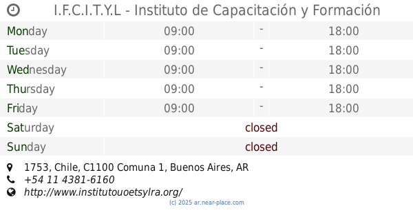
I.F.C.I.T.Y.L - Instituto de Capacitación y Formación de la Industria de Tintorerías y Lavanderías
Chile 1753
School
read more
676 m
IUNA Sede Once
Venezuela 2587
School
read more
871 m
Escuela De Guardavidas AMGAA CAPITAL
Presidente Luis Sáenz Peña 927, Buenos Aires
School
read more
872 m
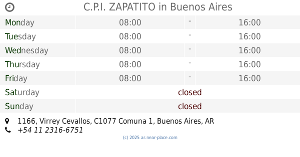
C.P.I. ZAPATITO
C1077AAX, Virrey Cevallos 1166
School
read more
886 m
Cens Número 58
School
read more
903 m
BUENOS AIRES CIUDAD JII N°1 D.E. 6°
Humberto 1º 2861
School
read more
945 m
Personalizados
Venezuela 1509
School
read more
954 m
MedicAR
C1079ABO, Avenida Entre Ríos 166
School
read more
955 m
secretaria de cultura y educacion
Avenida Hipólito Yrigoyen 2562
School
read more
962 m
colegio N°1
Avenida San Juan 1537
School
read more
1.032 km
Instituto de Ingles
Avenida Rivadavia 2530
School
read more
1.041 km
Tec 11
Cochabamba 2800
School
read more
1.059 km
Escuela normal bernardino rivadavia
Virrey Cevallos 1340, C1135AAD
School
read more
1.073 km
cens
Saavedra 15
School
read more
1.077 km
Escuela Técnica Nº 11 Manuel Belgrano
School
read more
1.08 km
Cens Número 06
School
read more
1.112 km
Escuela
Cochabamba 2838
School
read more
📑
all categories
Accounting
Administrative area level 1
Administrative area level 2
Airport
Amusement park
Aquarium
Art gallery
Atm
Bakery
Bank
Bar
Beauty salon
Bicycle store
Book store
Bowling alley
Bus station
Cafe
Campground
Car dealer
Car rental
Car repair
Car wash
Casino
Cemetery
Church
City hall
Clothing store
Colloquial area
Convenience store
Country
Courthouse
Dentist
Department store
Doctor
Electrician
Electronics store
Embassy
Establishment
Finance
Fire station
Florist
Food
Funeral home
Furniture store
Gas station
General contractor
Grocery or supermarket
Gym
Hair care
Hardware store
Health
Hindu Temple
Home goods store
Hospital
Insurance agency
Intersection
Jewelry store
Laundry
Lawyer
Library
Light rail station
Liquor store
Local government office
Locality
Locksmith
Lodging
Meal delivery
Meal takeaway
Mosque
Movie rental
Movie theater
Moving company
Museum
Natural feature
Neighborhood
Night club
Painter
Park
Parking
Pet store
Pharmacy
Physiotherapist
Place of worship
Plumber
Point of interest
Police
Political
Post office
Premise
Real estate agency
Restaurant
Roofing contractor
Route
Rv park, camping
School
Shoe store
Shopping mall
Spa
Stadium
Storage
Store
Subpremise
Subway station
Supermarket
Synagogue
Taxi stand
Train station
Transit station
Travel agency
University
Veterinary care
Zoo
sublocality level 1
sublocality level 3
↑