School nearby Camping Las Araucarias
Argentina
School nearby Camping Las Araucarias
Camping Las Araucarias
Ruta Nacional 22, Neuquén, Confluencia, AR Argentina
contacts phone
:
+54
Latitude:
-38.9558876
, Longitude:
-68.1870697
larger map & directions
read more
nearest School
494 m
E.P.E.A. N° 2
Ruta de Circunvalación 22, Plottier
School
read more
581 m
Puesto Plottier
Neuquén
School
read more
837 m
ESCUELA 265, PLOTTIER
Río Limay, Neuquén
School
read more
1.287 km
Metafísica para La Nueva Era De Neuquén
frente, Río Limay, Plottier
School
read more
1.351 km
Escuela Nº 234
Neuquén
School
read more
1.351 km
School No. 234
Neuquen
School
read more
1.416 km
Centro de Educacion Fisica N 108
Plottier
School
read more
1.425 km
Centro de Educacion Fisica N° 16
PALHUEN Y COLIHUE
School
read more
1.468 km
CPEM N°56
79, Calle Palhuen, Neuquén
School
read more
2.376 km
Academia Vial
Caracas 120, Neuquén
School
read more
2.654 km
Escuela cabecera 240 plottier
Alberdi 527, Neuquén
School
read more
2.738 km
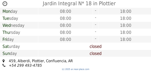
Jardin Integral N* 18
Alberdi 459, Plottier
School
read more
2.882 km
Esc. Integral de Jovenes con Discapacidad N° 4
25 de mayo 125, Plottier
School
read more
2.931 km
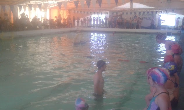
Natatorio Limay - Club Piap
Tromen 142, Plottier
School
read more
2.958 km
E.P.E.T N° 9 EDUARDO V.GATTI PLOTTIER
9 de Julio 16
School
read more
3.314 km
E.P.E.T N° 19
168, Doctor César Milstein, Neuquén
School
read more
3.314 km
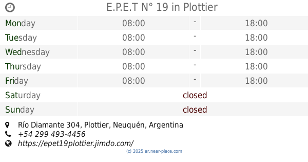
E.P.E.T N° 19
Río Diamante 304, Plottier
School
read more
3.32 km
Escuela
Doctor César Milstein 168, Neuquén
School
read more
3.541 km
Sole
Neuquén
School
read more
3.558 km
Cep N- 351
Doctor César Milstein 168, Neuquén
School
read more
3.84 km
Distrito Escolar X
Buenos Aires Sur 324-348, Neuquén
School
read more
3.845 km
Jardin Integral N* 39
Noriega 161, Plottier
School
read more
3.92 km
EPET N° 19
Alicia Moreau de Justo, Plottier
School
read more
4.068 km
Escuela 356
cuenca 16, Neuquén
School
read more
4.232 km
IFES - Colegio Secundario
Juan Julián Lastra 5600, Neuquén
School
read more
📑
all categories
Accounting
Administrative area level 1
Administrative area level 2
Airport
Amusement park
Aquarium
Art gallery
Atm
Bakery
Bank
Bar
Beauty salon
Bicycle store
Book store
Bowling alley
Bus station
Cafe
Campground
Car dealer
Car rental
Car repair
Car wash
Casino
Cemetery
Church
City hall
Clothing store
Colloquial area
Convenience store
Country
Courthouse
Dentist
Department store
Doctor
Electrician
Electronics store
Embassy
Establishment
Finance
Fire station
Florist
Food
Funeral home
Furniture store
Gas station
General contractor
Grocery or supermarket
Gym
Hair care
Hardware store
Health
Hindu Temple
Home goods store
Hospital
Insurance agency
Intersection
Jewelry store
Laundry
Lawyer
Library
Light rail station
Liquor store
Local government office
Locality
Locksmith
Lodging
Meal delivery
Meal takeaway
Mosque
Movie rental
Movie theater
Moving company
Museum
Natural feature
Neighborhood
Night club
Painter
Park
Parking
Pet store
Pharmacy
Physiotherapist
Place of worship
Plumber
Point of interest
Police
Political
Post office
Premise
Real estate agency
Restaurant
Roofing contractor
Route
Rv park, camping
School
Shoe store
Shopping mall
Spa
Stadium
Storage
Store
Subpremise
Subway station
Supermarket
Synagogue
Taxi stand
Train station
Transit station
Travel agency
University
Veterinary care
Zoo
sublocality level 1
sublocality level 3
↑