School nearby E.P.E.A. N° 2
Argentina
School nearby E.P.E.A. N° 2
E.P.E.A. N° 2
22, Ruta de Circunvalación, Plottier, Confluencia, AR Argentina
contacts phone
:
+54 299 493-3478
website:
www.facebook.com
Latitude:
-38.9569676
, Longitude:
-68.192608
larger map & directions
read more
nearest School
123 m
Puesto Plottier
Neuquén
School
read more
494 m
Camping Las Araucarias
Ruta Nacional 22, Neuquén
School
read more
1.331 km
ESCUELA 265, PLOTTIER
Río Limay, Neuquén
School
read more
1.414 km
Metafísica para La Nueva Era De Neuquén
frente, Río Limay, Plottier
School
read more
1.482 km
Centro de Educacion Fisica N 108
Plottier
School
read more
1.488 km
Centro de Educacion Fisica N° 16
PALHUEN Y COLIHUE
School
read more
1.528 km
CPEM N°56
79, Calle Palhuen, Neuquén
School
read more
1.619 km
Escuela Nº 234
Neuquén
School
read more
1.619 km
School No. 234
Neuquen
School
read more
2.43 km
Esc. Integral de Jovenes con Discapacidad N° 4
25 de mayo 125, Plottier
School
read more
2.685 km
Escuela 60
Gobernador Elordi, Neuquén
School
read more
2.69 km
Colegio Reserch
Manuel Lainez, Neuquén
School
read more
2.778 km
Escuela 98
Neuquén
School
read more
2.788 km
Esc 98
Aguas Claras, Neuquén
School
read more
2.795 km
Ipaf INTA
Alberdi, Neuquén
School
read more
2.803 km
Biblioteca Carmen Mellado
Misiónes, Neuquén
School
read more
2.856 km
Academia Vial
Caracas 120, Neuquén
School
read more
2.862 km
+QDANZA
Ruta Nacional 22
School
read more
3.085 km
Escuela Dis Multiples
Planicie Banderita 30, Neuquén
School
read more
3.093 km
Escuela Especial N° 13
School
read more
3.154 km
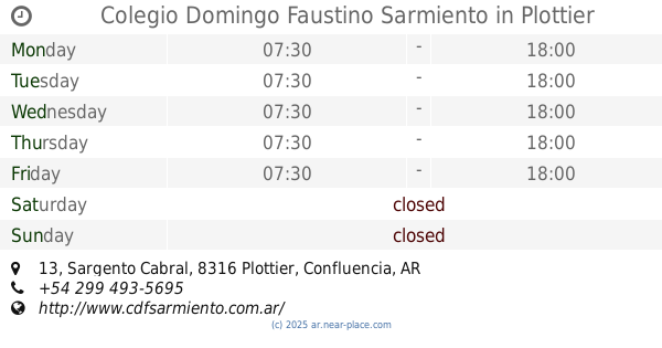
Colegio Domingo Faustino Sarmiento
Sargento Cabral 13, Plottier
School
read more
3.191 km
Cep N- 351
Doctor César Milstein 168, Neuquén
School
read more
3.225 km
CPEM 55 Plottier
Doctor César Milstein 168, Neuquén
School
read more
3.316 km
Sole
Neuquén
School
read more
3.93 km
Escuela N° 266
Avenida San Martín 1532, Neuquén
School
read more
📑
all categories
Accounting
Administrative area level 1
Administrative area level 2
Airport
Amusement park
Aquarium
Art gallery
Atm
Bakery
Bank
Bar
Beauty salon
Bicycle store
Book store
Bowling alley
Bus station
Cafe
Campground
Car dealer
Car rental
Car repair
Car wash
Casino
Cemetery
Church
City hall
Clothing store
Colloquial area
Convenience store
Country
Courthouse
Dentist
Department store
Doctor
Electrician
Electronics store
Embassy
Establishment
Finance
Fire station
Florist
Food
Funeral home
Furniture store
Gas station
General contractor
Grocery or supermarket
Gym
Hair care
Hardware store
Health
Hindu Temple
Home goods store
Hospital
Insurance agency
Intersection
Jewelry store
Laundry
Lawyer
Library
Light rail station
Liquor store
Local government office
Locality
Locksmith
Lodging
Meal delivery
Meal takeaway
Mosque
Movie rental
Movie theater
Moving company
Museum
Natural feature
Neighborhood
Night club
Painter
Park
Parking
Pet store
Pharmacy
Physiotherapist
Place of worship
Plumber
Point of interest
Police
Political
Post office
Premise
Real estate agency
Restaurant
Roofing contractor
Route
Rv park, camping
School
Shoe store
Shopping mall
Spa
Stadium
Storage
Store
Subpremise
Subway station
Supermarket
Synagogue
Taxi stand
Train station
Transit station
Travel agency
University
Veterinary care
Zoo
sublocality level 1
sublocality level 3
↑