School nearby Centro de Educacion Fisica N° 16
Argentina
School nearby Centro de Educacion Fisica N° 16
Centro de Educacion Fisica N° 16
PALHUEN Y COLIHUE, Neuquén, Argentina
contacts phone
:
+54
Latitude:
-38.9435978
, Longitude:
-68.1917486
larger map & directions
read more
nearest School
11 m
Centro de Educacion Fisica N 108
Plottier
School
read more
43 m
CPEM N°56
79, Calle Palhuen, Neuquén
School
read more
646 m
Escuela Nº 234
Neuquén
School
read more
646 m
School No. 234
Neuquen
School
read more
1.425 km
Camping Las Araucarias
Ruta Nacional 22, Neuquén
School
read more
1.488 km
E.P.E.A. N° 2
Ruta de Circunvalación 22, Plottier
School
read more
1.601 km
Puesto Plottier
Neuquén
School
read more
1.712 km
ESCUELA 265, PLOTTIER
Río Limay, Neuquén
School
read more
2.383 km
Sole
Neuquén
School
read more
2.405 km
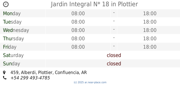
Jardin Integral N* 18
Alberdi 459, Plottier
School
read more
2.507 km
Escuela
Doctor César Milstein 168, Neuquén
School
read more
2.641 km
Esc. Integral de Jovenes con Discapacidad N° 4
25 de mayo 125, Plottier
School
read more
2.719 km
Escuela Especial N° 13
School
read more
2.73 km
Escuela Dis Multiples
Planicie Banderita 30, Neuquén
School
read more
2.817 km
Colegio Reserch
Manuel Lainez, Neuquén
School
read more
2.818 km
Cep N- 351
Doctor César Milstein 168, Neuquén
School
read more
2.841 km
Escuela 60
Gobernador Elordi, Neuquén
School
read more
2.854 km
CPEM 55 Plottier
Doctor César Milstein 168, Neuquén
School
read more
2.897 km
Ipaf INTA
Alberdi, Neuquén
School
read more
3.112 km
Academia Vial
Caracas 120, Neuquén
School
read more
3.193 km
Escuela N° 266
Avenida San Martín 1532, Neuquén
School
read more
3.279 km
+QDANZA
Ruta Nacional 22
School
read more
3.297 km
Escuela 98
Neuquén
School
read more
3.311 km
Esc 98
Aguas Claras, Neuquén
School
read more
3.32 km
Biblioteca Carmen Mellado
Misiónes, Neuquén
School
read more
📑
all categories
Accounting
Administrative area level 1
Administrative area level 2
Airport
Amusement park
Aquarium
Art gallery
Atm
Bakery
Bank
Bar
Beauty salon
Bicycle store
Book store
Bowling alley
Bus station
Cafe
Campground
Car dealer
Car rental
Car repair
Car wash
Casino
Cemetery
Church
City hall
Clothing store
Colloquial area
Convenience store
Country
Courthouse
Dentist
Department store
Doctor
Electrician
Electronics store
Embassy
Establishment
Finance
Fire station
Florist
Food
Funeral home
Furniture store
Gas station
General contractor
Grocery or supermarket
Gym
Hair care
Hardware store
Health
Hindu Temple
Home goods store
Hospital
Insurance agency
Intersection
Jewelry store
Laundry
Lawyer
Library
Light rail station
Liquor store
Local government office
Locality
Locksmith
Lodging
Meal delivery
Meal takeaway
Mosque
Movie rental
Movie theater
Moving company
Museum
Natural feature
Neighborhood
Night club
Painter
Park
Parking
Pet store
Pharmacy
Physiotherapist
Place of worship
Plumber
Point of interest
Police
Political
Post office
Premise
Real estate agency
Restaurant
Roofing contractor
Route
Rv park, camping
School
Shoe store
Shopping mall
Spa
Stadium
Storage
Store
Subpremise
Subway station
Supermarket
Synagogue
Taxi stand
Train station
Transit station
Travel agency
University
Veterinary care
Zoo
sublocality level 1
sublocality level 3
↑